Agricultural Impacts of COVID-19

Remotely sensed data can provide information about conditions on the ground that may affect food supply chains and food security during pandemics. Your challenge is to demonstrate the agricultural socio-economic impacts from COVID-19.

Forest Fire Monitoring & Detection System (with SMS Alerts)

Summary

Forest Fire Monitoring & Detection System (with SMS Alerts)Forest Fire Monitoring & Detection System (with SMS Alerts) In this project, a forest fire detection system is built with the help of Arduino UNO and GSM Shield for SMS alerts.gsmhome automation12,922 VIEWS7 COMMENTS23 RESPECTSCOMPONENTS AND SUPPLIESIm141125008 4Itead Gboard Pro 800 SIM800 GSM / GPRS Module 3.3v ATmega2560 Mainboard For Arduino Starter×1Ph a000066 iso (1) ztbmubhmhoArduino UNO×141vjwzaib4l sx425 iprkdeou4lDHT11 Temperature & Humidity Sensor (3 pins)×211026 02Jumper wires (generic)×1APPS AND ONLINE SERVICESIde webArduino IDE

How I Addressed This Challenge

ABOUT THIS PROJECT


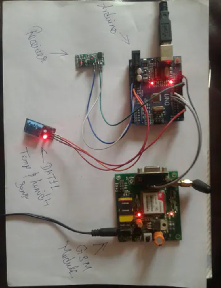
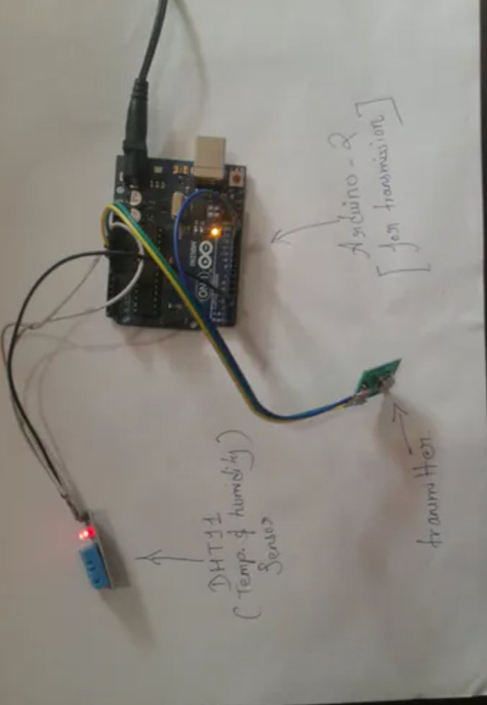
The process of detection of forest fire initiates at any of the nodes planted on atree inside the forest. The forest has a network of nodes placed at suitable distances from each other, the nodes have a capability to communicate through devices ( RF module in our case) and by using Arduino. If any change above a threshold value is found in the atmospheric parameters (temperature rise, contamination of air with smoke, etc.) near a node (source node), the information is passed to a nearest intermediate node until it reaches to the main/head terminal. The main/head terminal uses a GSM modem to pass the information to a cell phone (the forest fire)


The COVID-19 pandemic has profoundly impacted lives around the world in countless ways. To help learn more about one of these many impacts, Tall Timbers is working with the NASA Earth Science Division through their Rapid Response program, and the Forest Service Rocky Mountain Research Station, Missoula Fire Lab to measure and better understand changes in the use of prescribed fire during the pandemic. This research is part of an effort to help mitigate the negative consequences of the pandemic on the wildfire risk reduction benefits and wildlife habitat benefits of prescribed fire use.


In March 2020, as the pandemic began to spread in the United States, many organizations halted or reduced their prescribed fire programs to help maintain social distancing for those who conduct burns, and address uncertainty regarding the potential for smoke to aggravate COVID-19 symptoms. These changes overlapped with peak months for prescribed fire use in the Southeast. NASA satellites (MODIS and VIIRS) detected a 50% reduction in active fires in March 2020, and the reduction in fires has continued in the Southeast through fall-2020. The pandemic is now in position to impact a second peak prescribed fire season for the Southeast in early 2021.


A backlog of lands that need to be treated with prescribed fire already exists, and the federal government shutdown of 2018-2019 and the COVID-19 pandemic in spring-2020 have both added to this fire deficit. Fire is a natural process and without prescribed fire as a safe substitute, forest and grassland fuels accumulate and cause more destructive wildfires that can be negative for wildlife and society.


Therefore, my project is very related to this challenge, as it helps to detect fires early and send alerts to the nearest fire station in the conditions of the Corona virus.

How I Developed This Project

I developed it as it was initially just a drawing and engineering design on paper only, but then I started working on it using real equipment, which is


Itead Gboard Pro 800 SIM800 GSM / GPRS Module 3.3v ATmega2560 Mainboard For Arduino Starter


Arduino UNO


DHT11 Temperature & Humidity Sensor (3 pins)


Jumper wires (generic)

And then you define the parts that will serve as a physical part of the alarm and how it will send the messages,The forest fire detection module works in three different stages. The first stageconsists of reading some external environmental parameters like temperature andsmoke. The first stage is done with the help of some sensors which are used tosense and convert analog data to digital data. The sensors read parameters liketemperature, humidity and air quality then sends this information to the nextnearest node. This process goes on until the information reaches to the finalnode or the main terminal which is the second stage of the overall process. Thethird stage consists of transmission of the information to the forest firemonitoring unit.


Eachnode has a temperature and humidity sensor, a smoke sensor and amicrocontroller unit. Arduino has been used as the microcontroller device. Thesensors interact with the Arduino and store the information for comparisonprocess. There is a predefined threshold value to each of these parameters. Themicroprocessor compares the sensor values at regular intervals of times withthe threshold values. Based on the comparison if the input values of sensorsexceed the threshold the node transmits the information to the next nearby nodewhich again in turn transmits the information to the other nearby node. In thisway the message flow is regulated in this model.And I developed it so that it reached this form in front of you


PHYSICAL MODEL OF THE APPARATUS


TRANSMITTER PART OF PHYSICAL MODEL

How I Used Space Agency Data in This Project

I used NASA and its sites on Google to collect information and numbers, as well as the GPS control panel, and I also hired a software engineer to help me install the project


Project Demo

https://drive.google.com/file/d/1OFsisP0qssxIvgfC7l7H0QaykcqmA9jb/view?usp=drivesdk

Earth Observing Dashboard Integration

https://github.com/Hager148/Forest-Fire-Monitoring-Detection-System-with-SMS-Alerts-

Data & Resources

https://www.ompe.org/en/causes-et-consequences-of-forest-fires/#:~:text=Forest%20fires%20increase%20carbon%20dioxide,soil%2C%20causing%20flooding%20and%20landslides.


https://www.c2es.org/content/wildfires-and-climate-change/


https://youtu.be/72DBEkGgu-w


https://youtu.be/p9fbVPRlLGY


Earth Observing (EO) Dashboard


JAXA ALOS-2 (Advanced Land Observing Satellite) Data


Global Precipitation Measurement Mission (GPM) Data

Tags

#Agriculture #sustainable_environment #clean_environment #forests_without_combustion

Judging

This project has been submitted for consideration during the Judging process.